We will be holding four "regional" taste tests in 2022. Winners from each region will advance to compete in the “Best Tasting Water in Indiana” at our annual Fall Conference, October 26th, 2022 in Fort Wayne, IN.
Read more and register...
Grand Wayne Convention Center - Fort Wayne, Ind.
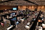
Thanks to you, we were back to "normal" with over 430 people in attendance! Thank you to everyone who participated in the conference at the Grand Wayne Convention Center.
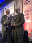
(Washington, D.C.) – If you’re looking for the some of the best tasting water in the nation, look no further than Mapleturn Utilities in Martinsville, Indiana. In this rural community, all you have to do is turn the faucet for pure “Quality On Tap!” Mapleturn Utilities claimed the Silver Medal of America’s Best Tasting Drinking Water at the 21st Anniversary of the Great American Water Taste Test, held on February 5, 2020 in Washington, D.C. as part of the National Rural Water Association’s Rural Water Rally.

Nashville, Tennessee
The National Rural Water Association (NRWA) recognized its first graduate with a Certificate of Completion from U.S. Department of Labor, Office of Apprenticeship at its annual conference on September 9, 2019 in Nashville, Tennessee with more than 2,000 in attendance.